Hezar Mountain is a mountain in Kerman province, that is located in the Rayen section in the south of this city and is the highest peak in Kerman province. Its height is estimated by accurate measurement by GPS device 4501 meters. Hezar Mountain, because of having a thousand different types of plants, is called Hezar and is the fourth largest mountain in Iran and the highest peak in the south of the country. The villages at the foot of Hezar Mountain, with their pleasant climate and the Rayen Falls, that is located in the heart of this mountain, receive many guests in spring and summer. Hezar Mountain with an area of 900 square kilometers is the source of Qahroud River. A short distance from the summit there is a shrine made of square porcelain stone, that resembles the shrines of the goddess Anahita. The highest residential area of Iran is Bab Zangi village, that is located in Hezar Mountain with a height of 3309 meters. There are several families living in this village and the villagers perform their vows on the top of the mountain. Bob Zangi village is also called Zangi. The people of this village live in this village in all seasons of the year, and in winter, due to snowfall, their communication route to the city of Rayen is cut off for a while. Khaleqabad, Khairabad are located; that attract many tourists in summer.
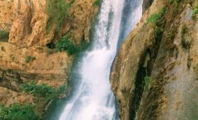
Ryan waterfall is on the slopes of Hezar mountain. This waterfall is one of the natural tourist attractions of Kerman province.
This waterfall falls 14 km southwest of the city of Rayen and on the slopes of the eastern front of Mount Hezar. The Rayen Falls is formed by the fall of a river that originates in the highlands and flows from the heart of the slopes and snow-covered walls of a thousand like a rooster. The Rayen Falls collapses in four stages, the first stage 3 meters and then 4 meters, the third stage from the edge of the precipice to the point where a large rock is locked in the walls and the next stage falls from the large rock to the rock floor of the waterfall basin and water on the wall It is a sloping rock and moves along the willows and along the side of a high rock wall.
Due to the presence of a groove at the waterfall, moving behind the waterfall and enjoying the coolness of the water particles creates an exemplary experience that turns into a simple and exciting ice climb in winter. Also, the main ascent route starts at the summit from the slope in front of the waterfall. The route continues up to an altitude of 3200 meters along the river and wild peppermint and flowers have covered the entire length of the road, he noted: This scene has created one of the most beautiful and glorious mountainous routes in Kerman province.